WHAT IS THE PACIFIC CREST TRAIL?
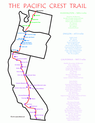
This image is from Yogi's Guidebook by Jackie MacDonnell
The Pacific Crest Trail is one of several National Scenic Trails in the United States. It is a hiking and equestrian path stretching from Mexico to Canada. It is approximately 2,560 miles long but no one really knows the length for sure, and it changes every year! For you geography buffs out there, you may have noticed that this figure is about 1000 miles longer than I-5. It is true! With all the switchbacks and meandering, the trail adds an extra 1000 miles to the distance!
The trail passes by the three deepest lakes in the United States (Lake Tahoe, Crater Lake, and Lake Chelan). It passes the two tallest peaks in the continental United States (Mt. Whitney and Mt. Rainier). According to the Wilderness Press Guidebook (2001) it traverses through "24 national forests, 34 wilderness areas, 7 national parks, plus numerous other parks and recreation areas." The highest point is 13,180, atop Forester Pass in the Sierra Nevadas of California, while the lowest point is a mere 150 at Cascade Locks, at the Oregon-Washington border.
The trail passes by the three deepest lakes in the United States (Lake Tahoe, Crater Lake, and Lake Chelan). It passes the two tallest peaks in the continental United States (Mt. Whitney and Mt. Rainier). According to the Wilderness Press Guidebook (2001) it traverses through "24 national forests, 34 wilderness areas, 7 national parks, plus numerous other parks and recreation areas." The highest point is 13,180, atop Forester Pass in the Sierra Nevadas of California, while the lowest point is a mere 150 at Cascade Locks, at the Oregon-Washington border.
Hiking the Pacific Crest Trail
There are generally two ways that people hike the PCT: one section at a time, or all in one go, which is called thru-hiking. I am attempting to thru-hike the trail. There may be detours for fires, and I probably won't even be able to find the trail for much of the time in the snow-covered High Sierra, but the goal is to walk in a continuous line from Campo, CA to Manning Park BC.
The average thru hiker walks between 15-20 miles a day (although some will hike as many as 40!), making the trip somewhere between four and a half and five months. Fortunately for us thru hikers, that is about how much time mother nature allows. There is a delicate balance between beating the snow in Washington's North Cascades and beating the heat in California's deserts. I am shooting to leave about April 19, 2013 and finish mid September which should get me to Canada before the snows hit (and more importantly, before the Stehekin Pastry Company closes!).
The average thru hiker walks between 15-20 miles a day (although some will hike as many as 40!), making the trip somewhere between four and a half and five months. Fortunately for us thru hikers, that is about how much time mother nature allows. There is a delicate balance between beating the snow in Washington's North Cascades and beating the heat in California's deserts. I am shooting to leave about April 19, 2013 and finish mid September which should get me to Canada before the snows hit (and more importantly, before the Stehekin Pastry Company closes!).
WHy am I hiking the pacfic crest trail?
In 2009, I ran across a book called A Blistered Kind of Love: One Couple's Trial by Trail by Angela and Duffy Ballard. The couple, who had never spent a night out in the woods together (Angela had never spent a night in the woods, period), attempted a thru-hike together. From my first floor dorm room at the University of Puget Sound, this sounded like just about the most exciting, challenging, and romantic thing I had ever heard.
During the next three years, I read every PCT book I could get my hands on. I convinced several friends to hike as well. I lived in Stehekin, WA, the last trail town before Canada, for a summer so as to meet as many thru-hikers as I could. I learned at a lot, but most of all, I learned that I wanted to hike the trail alone, solo. I have three friends and several acquaintances who will be thru-hiking this season, but I will carry my own gear, allowing us to acts a "loose confederation," free to hike together when we can, but able to split up as different needs and desires arise.
During the next three years, I read every PCT book I could get my hands on. I convinced several friends to hike as well. I lived in Stehekin, WA, the last trail town before Canada, for a summer so as to meet as many thru-hikers as I could. I learned at a lot, but most of all, I learned that I wanted to hike the trail alone, solo. I have three friends and several acquaintances who will be thru-hiking this season, but I will carry my own gear, allowing us to acts a "loose confederation," free to hike together when we can, but able to split up as different needs and desires arise.
